  Safety on the trail is a hot topic currently and apparently it's mostly in regards to women. This is my surprised face. I belong to a bunch of hiking groups for Ohio on FB, and in the last few weeks several women have asked a) if as a woman, they will be safe if they hike alone and b) what folks use to stay safe while on the trail.
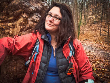
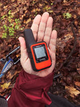
I was shocked at the majority of responses (over 80) that said gun & a CCW...and not one person, besides me, said a GPS satellite communicator amidst the spackling of other suggestions (pepper spray, don't hike alone, tell someone...basically another blog post at some point). Fuck that noise, noting that I have nothing against guns (I'm too clumsy to carry, not to mention I'm guessing someone would wait till they were right next to me to attack me and getting the gun pulled at that point would be quite difficult). However, this isn't to debate guns on the trails, but one particular way that can help you stay safe - GPS Communicators. Because, in reality, you're much more likely to fall, become seriously ill, etc. on the trail than you are to be attacked by a person. In fact, one of my biggest sources of anxiety was getting in to an area, having an issue like a seriously fall or coming across someone in need of help, and not being able to contact anyone. It freaked my family out, too. With the Garmin InReach, that's not an issue anymore - and I can see it's practicality, not just in hiking, but all sorts of situations - like a car accident in a rural area without service (check out my previous article on all the benefits of a GPS Communicator here). So what's awesome about it? Well, it's small - 3.9 x 2 x 1 inches and weights only 3.5 ounces. Weight reallllly matters to me with my back injury, and was one of the main reasons I hadn't picked one up previously. What I Love - pls bear in mind I have the cheapest subscription option...:
Downsides:
I've used the Garmin InReach Mini on quite a few trips now, and EVERY. SINGLE. MESSAGE I've sent has made it through, even when in valleys, in the snow, and it's overcast with tree cover. At some point, I'll go over one that I tried before the Garmin that wasn't quite as...successful, as well as how to stay safe against predators - both human and animal. Do you use a GPS Satellite Communicator? Why or why not? Do you like it? Leave a comment below or contact me here!
1 Comment

Charlie on the trail, much happier that I now use AllTrails.
One of the big problems getting started with outside adventuring has to do with access. Beginning hikers and walkers can find it difficult to determine if a trail they find online is appropriate to their ability, if they can even find trails around them. Once they find a trail, they want to know what the terrain is like and if there are any obstacles. Are trail bikes welcome? Horses? What about finding the trailhead? Navigating the trail? Any special wildlife areas they should be aware of, like bat habitats? Is it safe for their therapy or service animal?
I've had a number of folks the last few weeks ask what I use to gain access to the outside world, and my go to right now is AllTrails. Hands down, this is the best app I've found to give beginners - and experienced hikers - the access and information they need to get out in the outdoors. Six or seven years ago, I got lost on a Cleveland, OH trail. I had a printed map of the park, but the trails in the Metroparks aren't very well marked in most cases. It was cold and snowing. I had no cell reception and it was getting dark - of course I hadn't brought a headlamp/flashlight. The parks aren't all that big, so I knew I'd eventually find my way out. An hour after dark, my dog Charlie Chuckles and I made it back to the car. I was tired and reallllly pissed off.  It was really, REALLY cold. It was really, REALLY cold.
And this wasn't the first time I'd gotten turned around on the notoriously ill-marked trails in the Cleveland area. Or been unable to find a trailhead with sketchy directions from the internet. Then came AllTrails. Queue rescue-themed music. AllTrails has been wonderful, and really opened up my access to trails in the Cleveland, OH and surrounding areas. Trails I doubt I would have found, or had the courage to try, without it. AllTrails is awesome - You can select what you want out of a trail and search for it - distance from your home, dogs allowed, length of hike, trail bike accessibility, difficulty, etc. This makes it a great tool for folks with disabilities that need to know if a trail is paved, if there are amenities at the trail head, etc. A nice bonus is that you're able to read reviews and see pics of the trail - great way to check for mud or other problems like downed trees/washed out trails. And it's free. Hiking and outdoor adventuring is already prohibitively expensive for many, and anything that removes additional spending is great (pro-version is $2.50 a month, and gives you access to download/print different topo maps). You can use it to track yourself AND record your hike while on the trail, even when your phone is in airplane mode. AllTrails also has a directions option that will open your phone's GPS app and take you right to the trail head. This is A-mazing. Previously, I found myself constantly lost on back roads, and a few times I even gave up on the hike. As a new hiker finding remote trailheads was incredibly frustrating. It helps build confidence, since you can view nearly all the trails immediately around you, allowing you to add/shorten your hike as you want or need to. 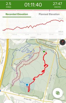
You can see where you've been, options to lengthen or shorten your hike/ride, and your pacing.
There are a couple downsides to AllTrails to keep in mind - it's not always 100% accurate in regards to length of the trail. I find the trails are often a half mile to a mile longer than indicated.
Keep in mind the difficulty rating of the trail tends to vary wildly. I did a 9 mile moderate trail last weekend, which was, to my surprise, easily and quickly accomplished even though it was pouring rain and I had to take a lot of breaks. Whereas I did a trail a few months ago that was five miles and very hilly, difficult terrain. Both were rated as moderate. I always encourage folks to have a printed map with them as well, and to understand how to read it, especially if you're in larger parks/national forests. Despite these issues, I recommend AllTrails for the access it provides. Have you ever gotten lost on the trail? Do you use an app or stick with a map, or both? Comment below, or feel free to contact me here! |
Archives
March 2021
Categories
All
|