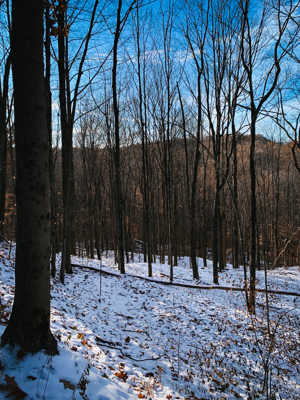
 I've been processing my last solo trip for a little while, which was to Wildcat Hollow in Southeast Ohio. I love Wildcat. It's challenging with elevation, lots of spots to stop, pretty, has bug out points, and is perfect length for a weekend. That's why I love solo-ing there.....correction....LOVED solo-ing there.
. The last time I stayed there I was down in the spooky-ass valley. I got there as dusk was falling, the camp I wanted to stay in was taken. So I'm in the mostly overgrown, super creepy camp spot. The ONLY spot I get icky vibes off of. Of course. And it was cloudy. SO ZERO LIGHT. . Whatever, I'm badass and awesome, so I just trundled off to bed with Lucy, my mostly fearless companion....and a book on tape to drown out my own imagination. . Let me say I felt pretty comfortable. I wasn't *super* creeped out, just my own imagination running wild. I fell asleep, feeling good. And then was awoken at 1:30ish to light beaming in my tent. WTAF. WTAF. WTAF. Bear spray in hand, I peered out. First thought was aliens. Second thought backpackers coming in late after work. But I could see them on the trail, about 40 feet away, flashlights in hand and stumbling along, no packs visible. Roads intersect Wildcat and they seemed drunk or high, so I guessed they were out there to party. My campsite was overgrown, and it was very foggy, so I figured they didn't see me (Lucy just crouched low to the ground and stared, not barking for once lol). I waited about fifteen minutes, prayed I wouldn't have to pee, and then snuggled back to bed with Lucy. Quite proud of myself, I'd like to mention. . Then the FUCKING GUNSHOTS STARTED. Two in the morning, and close. Like, it could be the guys kinda close. And not one or two, like 20 or more. I noped the fuck out after that. Lucy was losing her shit, terrified. I was afraid but not terrified, but I wasn't sticking around. I jammed everything in my pack, called my dad to come meet me at a random road, and hiked four and a half miles out. . There were a lot of things that ran through my head - one dude just murdered another and I was going to see a body that night (drug deal gone bad? illegal dumping? all of those things are present down there). Or, more likely, two drunk dudes illegally poaching deer. Didn't wanna run in to them doing that, either. I grew up 20 minutes from there. Not folks you want to run in to. . It was legit scary. But I'll tell ya what - I didn't panic. I assessed the situation, deemed it no longer safe to remain, and got myself out of the situation. And I don't feel bad for bugging out. I go in to every solo (and regular bp trip to be honest) with a solid foundation of what to do if shit hits the fan - what are the ways out of the woods? Who do I call? Do I have a means to get help if I can't get out? Do I have a means to survive the most obvious situations until help arrives? . These are all questions you should ask yourself - and have answers to - every time you go out in the woods, whether to hike or backpack, alone or with others. . In the weeks following my bug out, quite a few folks in my hiking groups have mentioned staying at Wildcat and the significant amount of gunfire they heard while there. Not just me. It's frustrating, but also good to know. . I WILL be solo'ing again, and I'll post some of my theories at another time. . What's the worst thing that's happened to you at night while backpacking? Solo or with others? How did you overcome it?
1 Comment
 Wild Cat Water - water water everywhere and not a drop to drink? Sorta.
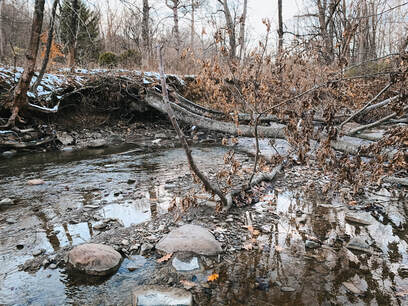
A few people commented or sent messages regarding the water situation at Wild Cat Hollow in southeast, Ohio, for which there is a surprising amount of confusion based on responses to a post I made in a hiking group asking about it. There are quite a few streams which are running at Wild Cat right now, thanks to all the Spring rains. I would imagine that in summer/fall most of these streams would be dry. I carried 3 liters of water with me, just in case when I went, and I ended up filtering twice for more. HEAVY METALS: I didn't know this when I first started planning my trip, but southern Ohio used to be KNOWN for mines of all sorts. And while most of them are closed, the runoffs from the mines have tainted a lot of the water sources with heavy metals. This means that if you're going to filter water, you need to MAKE SURE you're filter will filter heavy metals (along with all the other icks in the water). Really, this is important. Heavy metal poisoning is a THING. And while there I saw a number of folks using the wrong types of filters. If you don't want to mess with filtering water, or taking a chance the streams might be dry, then there's another option - caching water. There's several roads that traverse Wayne National Forest (where Wild Cat is) and it's easy enough to stash a couple gallons of water. Make sure they're sealed gallon jugs, and put your name on it/initials, and "cached water" so people don't toss it. The downside is navigating those back roads to find a cache location, but if you use All Trails, you'll be able to find where road meets trail fairly easily. Lastly, people wanted to know what filter I use - it's the LifeStraw Flex with Gravity Bag Water Filter by @lifestraw. It's hella light, acts as a back up water bag, and yes, it exceeds the NSF 53 standard for reduction of lead and other heavy metals and NSF 42 for chlorine. What water filter do you use? 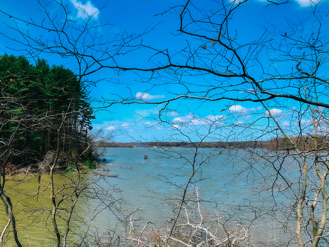 It was at West Branch State Park, which has two large loops. This is good for avoiding folks during the pandemic. I'll do a full review of the trail later, but it was a lovely one. The first six or so miles followed closely to the reservoir, which was beautiful. This will sound weird, but I actually had a dream the previous week about hiking a longer trail. I hadn't planned to, I was going to stick to my normal 10 mile weekend one. But on Saturday morning, as I was driving to my normal loop, I went to put on the directions from All Trails and this one - literally across the street from the one I normally do - popped up. It said 11 miles and I figured, "PERFECT." Of COURSE with All Trails, I should of figured it would be longer. Lucy and I even set up the camp stove for lunch at the turn around point. I wish I could say I sat there, looking out over the water, thinking deep thoughts, but truthfully I just pet Lulu, ate some food, and listened to my book on tape. I didn't see anyone on the first leg, but I did on the second - two rabbit hunters running their dogs, who were in the wild life portion. The dogs eventually found us on the trail but were VERY nice. The second gentleman I encountered was also very nice - and carrying a pistol - which was a little unnerving. I walked through the pines. I walked through the trail that meandered up a creek bed. I saw the view of the water and trees across the way. I saw fields. I saw many a fallen tree. I saw the old rock wall in the quarry. I heard the haunting sound of baying hounds as the wind carried it to me. It was amazing.
I did it. I didn't have anxiety about it. And truthfully, while I was tired and ready for a real break, I wasn't exhausted. I even went out the next day for another hike on Easter. My back held up. Lucy held up. We did it. It's taken a long time to get there, but we did it. Even in dark times, there are spots of light. What adventure did you get in to this weekend? Comment below or feel free to email me here!  This past weekend, Lucy and I took to the wide-open road and drove about an hour out to Ravenna to try a new portion of the Buckeye Trail – the West Branch Loop – which looped around the Michael J. Kirwan Reservoir. It was a lovely trail, for the most part, and really challenging! It took just about six hours for us to complete it (we stopped for lunch partway through for a half hour), and I’m glad I had my headlamp. It was completely dark by the time we got back to the car. Read on to find out why and to check out all the pics! Details: -Length: 9.4 miles -Elevation: 535 ft. The Good: -It had some very beautiful spots, really gorgeous. I bet it’s awesome in summer! -It was remote – I didn’t see anyone else on the trail, and for most of it couldn’t hear any cars, etc. -Enough of a challenge to make it interesting The Bad: -Because it doesn’t seem to be traversed often, you really gotta keep your eyes open for the Buckeye Trail blue blazes that are painted on the trees. Some are faded, and some are spread a little far apart. I didn’t have any issues and didn’t have to backtrack at all, but you DO really need to watch. I *did* check my AllTrails App a couple of times, just to be sure I was on the right path. -Remember how I mentioned it was a really challenging hike? That’s because the first half of it was definitely in a state of thawing mud – I’ve never been on a trail like that before – where the mud took on this half frozen weirdly inflated feel. So basically every time I stepped my foot went down and in different directions. Not sure how else to describe it, but it made for slow going and really sore feet the next day. So hiker, beware! May want to wait until it’s dried out a bit more. The Ugly: -Holy crap – there are two places, at either end of the loop, where you have to walk on the road for a little bit. Fairly common with the BT. 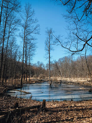
The Good:
-It had some very beautiful spots, really gorgeous. I bet it’s awesome in summer! -It was remote – I didn’t see anyone else on the trail, and for most of it couldn’t hear any cars, etc. -Enough of a challenge to make it interesting The Bad: -Because it doesn’t seem to be traversed often, you really gotta keep your eyes open for the Buckeye Trail blue blazes that are painted on the trees. Some are faded, and some are spread a little far apart. I didn’t have any issues and didn’t have to backtrack at all, but you DO really need to watch. I *did* check my AllTrails App a couple of times, just to be sure I was on the right path. -Remember how I mentioned it was a really challenging hike? That’s because the first half of it was definitely in a state of thawing mud – I’ve never been on a trail like that before – where the mud took on this half frozen weirdly inflated feel. So basically every time I stepped my foot went down and in different directions. Not sure how else to describe it, but it made for slow going and really sore feet the next day. So hiker, beware! May want to wait until it’s dried out a bit more. The Ugly: -Holy crap – there are two places, at either end of the loop, where you have to walk on the road for a little bit. Fairly common with the BT. Probably around a mile and a half or two miles total. Not a super big deal, but the one side for about a half miles was a VERY busy road. Semis and cars driving by one after the other at high speeds, and you have to walk about 3 feet from them for most of it due to a bridge with no sidewalk. HIKER BEWARE. It felt dangerous and I carried my dog for the duration of it. In the end, I'll definitely do it again some Saturday. Lovely day hike. But I'll wait, for sure, until it's dried out a bit! Have you hiked West Branch Loop or another portion of the Buckeye Trail? Comment below or email me here! 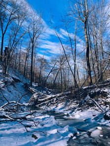 This is from my first real winter hike of 2020, where the ground was frozen, the air crisp, the sky clear, and the beauty was REAL. I doubt I would have given this trail a try, if I hadn't strained a muscle and needed something a bit more on the chill side. Normally, I much prefer loop trails – I’ve found I really dislike retracing my steps on a hike. While I’ve found I can do the same loop over and over, covering the same ground in the same day makes the hike feel MUCH longer to me. I’m very glad I got the opportunity to hike this trail – it’s very pretty and removed from the road for the most part. It’s shorter – 3.3 miles – without much elevation, so it’s ideal for those just starting out, folks with minor injuries, or if you just want a quick out and about. They called it a “primitive trail,” which meant it narrowed to single file in sections, but was otherwise well maintained and very easy to follow/well marked.
Here’s all the pertinent details: · Loop Trail · 3.3 Miles · 308 Ft. Elevation · Dogs Allowed: Yes · Wheelchair Accessible: No Positives · I didn’t see anyone else on the trail, despite the “moderately trafficked” rating on AllTrails. My guess is it’s fairly deserted in winter. · It’s very pretty in spots, with several minor creek crossings. · There’s an archery range at the trailhead, be kind of neat to do both in a day! (note: have to bring your own bow/arrows, but it’s free and open to the public) Negatives · The “Top of the World” was a bit confusing. I went the little extra bit to check it out, and truthfully, I didn’t think the view was all that – it was pretty, but nothing really out of the ordinary. · It’s 3.3 miles – a very pretty hike, but the downside is that this loop doesn’t connect to any other trails in Cuyahoga Valley National Park, so there isn’t really an option to extend your hike if you want to. Have you hiked Adams Run? Have a trail recommendation? Let me know below or email me here! 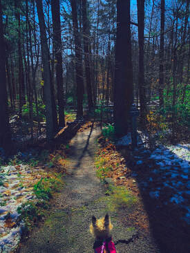
Little Dog, Big World.
 Lucy pondering how McDonalds is life. Lucy pondering how McDonalds is life.
This past weekend, Lucy and I decided to do an adventure of (semi)-epic proportions. So we donned our gear, grabbed some food to take with (McDonalds, don't judge, Lucy has a very refined pallet) and drove down to Cuyahoga Valley National Park to check out a- supposedly- 5.5 mile loop comprised of three separate trails - Perkins, Riding, and Furnace.
But it wasn't 5.5 miles - it was nearly 8. And TOUGH. SURPRISE B! I'm always surprised by what my body is capable of, which apparently is some big ass hills. Read on to get the scoop on the trail and all about our adventure! 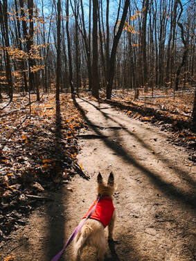 Lucy pondering why there aren't any leaves. Lucy pondering why there aren't any leaves.
The entire trail was beautiful - really lovely - with a lot of changing scenery. If you're up for a good challenge, I'd highly recommend it.
To start, Perkins - just magical, with moss covered trees and glinting light. The weird? SOMEONE CAME THROUGH AND LEAF BLEW THE TRAIL. I was super confused. It made the trail seem weird and unnatural. And privileged in a way that made me uncomfortable. I'll talk more about this in another post. All three trails had a LOT of elevation (three and a half near mountain limits of 1000ft.). The entire trip was basically "up/down up/down." Frankly, I was surprised by how well I held up.
 The tree I used as a bridge. The tree I used as a bridge.
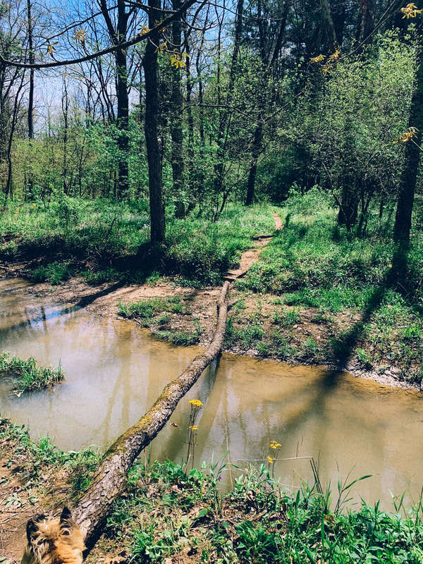
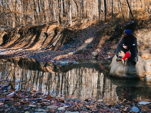
After heroically carrying Lucy through the briars, I wasn't going back through it. So I finally found a place to shimmy down. Then I had to cross - which I did by walking across a log. Even in winter, the water was knee high. I'm guessing even less passable in Spring.
I'm sure the rest of Furnace was pretty, though by the time I got through the creek I was beat, dusk was falling, and I still had 2 miles to go....SURPRISE....as I was already at 5 miles.
The last 1/2 mile of Furnace was comprised of dozens of stairs. Not great.
Wrap-Up: It was a real challenge, mainly due to the elevation and the distance I hadn't planned on. I felt *really* good about it at the end - my back held up with the pack. I'd definitely do Perkins and Riding again, but would dodge Furnace. Have you ever been surprised by the length of a hike? Or a trail "disappearing"? Comment below or contact me here. 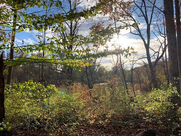 The Emerald Corridor This is my favorite hike at the moment. There are parts where I really feel in the woods, and because of the varied, beautiful scenery I like to pretend I’m like Anne of Green Gables, giving unique, totally overblown names to all the different sections.  When I started hiking again, I was self-conscious and had a lot of anxiety about it. I had to go slowly, take a lot of breaks, and the hiking clothes, while awesome, were still more form fitting than I wore at the time. Plus, I was a fat girl, all alone, trying to figure out how to be on the trails. I didn’t really want to constantly run in to dudes on the trail that inevitably give me the look. Or would say things in a patronizing manner like, “Only a few more miles to go! Don’t stop, keep working up that sweat!” Uh, thanks random guy. I wanted to take my dog, enjoy the outside, and figure shit out for myself without worrying about what others were thinking/going to do. And that’s what Sagamore Creek Loop provided….. 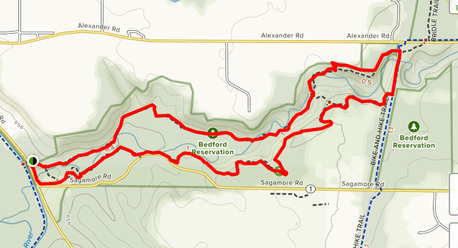 Map courtesy of AllTrails 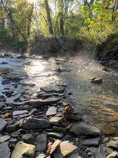 Location The Sagamore Creek Loop Trail head is located at 7733 Canal Rd, Valley View, OH 44125 (Frazee House Parking Lot) and is part of the Bedford Reservation, near Bedford, OH. The easiest way to access the trail head is behind the outhouse, and take a left when you get to the bottom of the incline. The Good
The Bad
 Note: At the beginning of the hike, you'll pass a place on the right where you can cross the creek. You'll do this at the end of the hike to complete the loop - I mention this because the alternative ending on the other side is NOT crossing the creek, but a muddy bog and ending the hike with a quarter mile walk on a main road.
The Ugly
Accessibility: Not wheelchair accessible. Sagamore Creek Loop remains, by far, one of my favorite hikes. When I first really managed to get hiking again, Sagamore provided the reclusive atmosphere I yearned for, where I first recognized that I could this outdoor thing, despite the pain/anxiety/etc. It’s the first trail I ever completed a night hike on. It will forever hold a special place in my heart. Do you have an outdoor space that’s special for you? Leave a comment or drop me line here!  |
Archives
March 2021
Categories
All
|